MSR’s Hubba Hubba NX Tent – Review

15 03 2015
msr hubba hubba nx,gear shed,camping,camping oregon

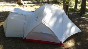
The Hubba Hubba NX with the Gear Shed

I’m the proud owner of a brand new Mountain Safety Research – MSR Hubba Hubba NX ultralightweight backpacking tent! With 27-year-low snowpack in Oregon’s Cascade Mountains, I couldn’t wait to try out my new tent. I also bought the “Gear Shed” attachment for the tent. So, I headed up to Clear Lake near Mount Hood, Oregon to set up and sleep in my new tent.

The MSR Hubba Hubba NX is a super light two-person tent – only 3.7 pounds! But any tent I’m going to be pleased using has to be easy to set up and durable. And on warm summer nights I like to set up the tent without the fly. This allows for star gazing and cooler sleeping. But some tents have a very shallow “bathtub” around the bottom, allowing breezes to get through, and onlookers to see you when you’re dressing. I like tents where the “bathtub” is a bit higher.

As a backpacker and kayak camper, I also want a tent that’s easy to set up in the dark. No complicated setups. I also like tents with reflectors so at night I can shine a light on them and see it from far away. Gear vestibules are also super important. I want my shoes and gear to stay dry even if it’s outside my mosquito-lined sleeping area. For windy days tents need to be guyed out. There must be ways to secure the tent to the ground, so it doesn’t blow away.

So with these needs / wants in mind I set about testing and setting up the MSR Hubba Hubba NX. Unpacking it from the bag, I immediately noticed thoughtful touches. The bag kind of cinches up like a cradle. The bag has outside straps enabling it to be scrunched down like a compression sack.

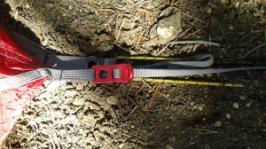
I set out the tent footprint and then laid the tent on top of it. I staked out the corners. Right away I noticed a clever detail where the attachment of the tent to the stakes takes place. A sturdy cinchable strap-to-stake attachment point. Nice!

msr hubba hubba nx

The tent pole goes thu this grommet. But you can tighten the strap to the stake. Thoughtful!

I unpacked the tent frame. On the MSR Hubba Hubba NX there is only one frameset where all the pieces are connected via shock cord. It’s made of DAC Pressfit aluminum. Light and durable. But you need to be careful and deliberate about connecting. I fear splitting a pole end if I am in a hurry.
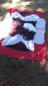
msr hubba hubba nxI laid the frame on top of the staked-out tent.

The next step is to connect all four corners and the top center piece to the frame. It’s a little challenging do do alone but with practice it will be easy.

msr hubba hubba nx

Frame connected and ready for clips

OK. So now, the next step will be snapping the clips to the frame.

It’s here I notice another thoughtful and durable touch.

The clips are shaped to fit snugly around the poles, but there is more. The load of the clip is spread between two attachment points on the tent. This reduces stress points on the stitching on the tent.
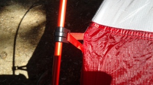
msr hubba hubba nxSo far, I’m delighted with the thoughtful, clever details of this tent. And all for 3.7 pounds! Next step is to connect the clips. Once done I’ll have the full volume of the inside.
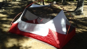
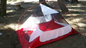
msr hubba hubba nxThis is how nights under the stars will be. This is how I like things – there is a good view of the sky above, and ample ventilation – but the bathtub walls are high enough to shield occupants from wind and from onlookers.

Next, the fly. A fly should be able to keep rain out but also allow for ventilation – and especially bonus points are awarded for flies that can be unzipped without rain dripping into the tent.
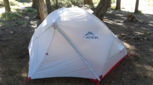
msr hubba hubba nxVoila. with the fly attached, and the vestibules stakes out, there is actually a lot of acreage to store packs and shoes out of rain’s way. Two tent mates each have a vestibule and exit for themselves. Inside the tent, on each end, there are tent-wide gear pockets. Enough for most any backpacker’s needs. Up above, there are attachment points so you can sling strings – from which you can dry your stanky socks. Unfortunately two things are lacking – Firstly, a distinct shortage of attachment points for guy lines and secondly, no reflective piping.

But let’s say you have need for even more room. You have a disagreement with your tent mate. Or perhaps there is a 3rd soul needing a place to rest for the night. Or you’re car camping with executive camping gear and you’re needing extra storage space. For that, the MSR Hubba Hubba NX offers a solution: The Gear Shed.

The Gear Shed doubles the available storage space. Or can be used to accommodate another camper – or a Man’s Best Friend? If you have the MSR Gear Shed, you have options.
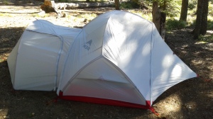
20150312_153922What’s the verdict? Well, although I love this tent and gear shed setup, it’s not 100% perfect. Somehow designers left out reflective materials. At night I bumped the corners more than once. And I have to wonder about its ability to hold up in the wind without lots of guy line attachment points. Still, I love the MSR Hubba Hubba NX and it’s a keeper. I can recommend it!
Oregon’s Gold Rush Region! Sumpter, Oregon and Granite, Oregon

6 09 2013

Route MapMy interest on this trip was focused on the areas around the North Fork John Day River Wilderness Area. I’d be driving Oregon’s Route 7, Route 73, Route 20 and Route 52. Today, I’d pass through Prairie City – on state highway 26, on my way to Sumpter, Oregon. This is 100% marked as scenic on the maps!

I’d be camping at Anthony Lake, though I didn’t know it when I began. I will tell you the drive along Oregon’s Highway 26, the Journey Thru Time Oregon Scenic Byway, is serene and calming. It wends its way through ranches and farms and small towns like Mitchell and Dayville, with less than 250 population. Absolutely nobody is in a rush here.

A few dozen miles east lies Prairie City. They’re making an effort to refresh main street here, and it looks pretty. I fill the tank with gas, and here they still clean your windshield! Then Oregon Route 7 intersects, and I’m on my way up to the Elkhorn Mountains, climbing all the way.

This is GOLD RUSH territory! In 1883 Sumpter was founded. By 1897 a railway reached the area, and the population grew to 2,000 as gold mines and claims proliferated. There were 12 miles of underground tunnels. Even today, I saw staked out gold mining claims!

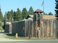
Fort SumpterThese days Sumpter is preserved as a tourist attraction of Gold Rush history. Much of it has been restored to look as it was. I even saw a fort. I wondered if that fort was supposed to look like the Civil War Fort Sumpter? To me, it looked like it was right out of the 1960s TV series “F-Troop.”

Two of Sumpter’s main attractions are the Sumpter Valley Railway and Sumpter Valley Dredge. The railway, opening in 1890, was built to haul lumber 22 miles to Baker City. Within two years it was hauling passengers and freight. Today, it is a 6-mile narrow gauge tourist ride.

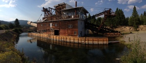
The Sumpter Valley Dredge is a monument to capitalism and 19th century technology. These 4-stories-tall dredges floated in ponds, and as they dug, the ponds moved with them. They consisted of conveyor belt of buckets to dig earth and carry inside for processing, the internal processing machinery, and another conveyor out back to dump out the waste. There were three of them in the valley. Ironically even though they only employed three workers each, they ended their machine-lives $100,000 in debt. Sumpter Dredge

Climbing out of Sumpter, the road switchbacks ever higher. I drive along a high altitude creek lined with mining claims, and with piles of rocks which could only have been left by days-gone-by gold prospectors.

Then I reach Granite, elevation 4,695. Granite’s population is 38. It looks bigger than that. It’s got a “Welcome to Granite” sign over the road. It’s got a fuel depot and a hotel. Still, it has a look and feel of a genuine frontier town. Founded in the 1880’s, granite boasted a population of 86 gold miners by 1940, but in WWII, the government ordered gold mining shut down to make miners dig for “esseFire Crew Signntial war effort” materials. Granite collapsed, and never recovered.

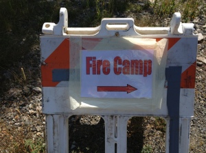
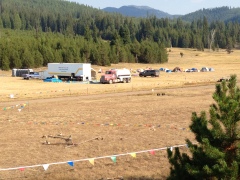
Past Granite, I made up my mind that I would camp at Anthony Lake, some 40 miles distant. I’d be cruising the Elkhorn Oregon Scenic Byway. On my way to that byway I ran across something unsettling – a Forest Fire Camp. During this trip there was a giant fire threatening Yosemite National Park, so forest fires were in the news.

Yet I didn’t know that the Forest Service established camps supporting hundreds of firefighters even before a fire started. Wow. That is serious.

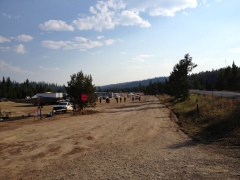
Fire Crew StationThe camp I saw was several acres, high in the mountains, in a big meadow. And as big as it was it was clear that there was room for probably a thousand men up there.


Fire Crew2That made me much more aware of the gravity of the situation.

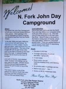
Beyond the Fire Camp, I ran into something I came out here for. It is the trailhead for the backpacking trail on the North Fork of the John Day River. I had heard about this many years before and now I was here. Too bad I am injured now, and can’t do it. But I will be back.

NF John Day SignIt’s very very pretty up here, and there are just not a lot of people to bother you. That is the beauty!

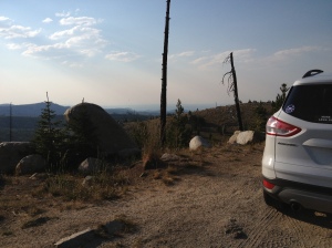
I decide to push east and camp at Anthony Lake. I have been there to ski in the winter, but never seen it without snow. I just have to check it out. On the way I reach a high point in the Elkhorn Moountains, about 7,250ft.Elkhorns 7250

The view goes on forever. It seems a high plateau goes on from here and one could backpack quite a ways.

Then I descend down into the Anthony Lakes area.

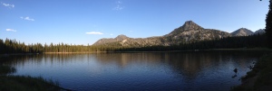
The lake is much smaller than I remembered, as I had cross country skied around it two times in the past.

Anthony Lake PanoramaI had imagined it would have campsites on it. But nope. The campground is to one side, and it has day use areas on the other. There are walk-in sites to another side.

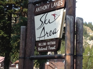
I also paid a visit to Anthony Lakes Ski Area.Anthony Lakes Sign


Without snow, it looks so different. I quickly realized I could actually drive around the lodge and onto some of the lower slopes I had skied!

This was pure devilish fun! Well, with that bucket list item checked off, I returned to the campground and made my meal. I grilled a pork chop, made mashed potatoes, had an awesome campfire, and salad. Then, off to sleep.

I had hoped to see a million stars – but that was not to be. The smoke from the Yosemite fire partially obscured a picture perfect view. Next time I guess!


xx


Metolius and Big Lake, Oregon

27 06 2011

I returned to the Metolius River area because the weather there was forecast to be 70 degrees and sunny. I’d planned to check out some areas near Yale Lake, WA, but the weather up there was due to be poor – drizzly and 55 degrees.

Clouds breaking up at the crest of the Cascades

I don’t know if it’s because I like to spend time outside, or if it’s because I’m living in Portland, Oregon, where it is dismally cloudy each spring, but in the summer I get a salmon-like cabin fever drive to get out of town and enjoy the beautiful weather in the summer. I really feel like any free time spent in town is wasting opportunities to squeeze in as much outdoors time as possible!

So I chose to go where the weather looked great. And that meant Metolius. Metolius sits in a valley, and just to the west lie Oregon’s Mt. Washington, Three Fingered Jack, and Mt. Jefferson.

Nice yard view.

There are a few homes in the valley with backyard views of these peaks. In this early summer, with so much green in the valleys and the white of the mountains, the view is eye-popping.

On my way to Metolius, the highway passed Hoodoo Ski Area, and just behind Hoodoo sits a recreation area I’d seen on my map called Big Lake. Not in any hurry, I stopped in to Big Lake. The elevation is 4,650 feet, since it’s right on the high Cascades pass.

The road to Big Lake led through 6 – 8ft tall snow drifts on either side. The road led to a campground on the lake, which had spectacular views of Mount Washington.

Much to my surprise, the campground was completely empty. My guess was that the snow had just melted enough to allow vehicles in.

It was lovely and warm. So I took my kayak out for a paddle, exploring its back marshes and coves. There were no bugs – but as there were a lot of snow melt pools nearby, in two weeks the mosquitoes will be unbearable. But on this day, it was bug-free and all mine!

I could see that Big Lake might not be a good choice in mid-summer. It’s got a lot of ATV trails nearby…I could imagine lots of RVs pulling noisy ATVs and the campground full of noisy RVs and their generators…but today, it was quiet and lovely!


Memorial Day Camping along Oregon’s John Day River – Escaping the Rain!

30 05 2011

Lazy days in Mitchell, Oregon

2011 has been one of the rainiest/coldest on record in Oregon. With only a few sunny days in the 70’s, May has felt a lot like February! The summer season typically kicks off in Oregon’s Cascades around Memorial Day but in 2011, all the mountain campgrounds are still under snow!

Solution? Head east! Oregon’s reputation for rain belies the fact that most of the state is high desert.

When most Oregonians think “high desert” they think the Three Sisters / Bend region. While that area has great weather and is beautiful, it’s become full of tourists.

Truly beautiful and overlooked is the region between Condon / Service Creek / Spray and Mitchell. Head there and you’d think you were in northern Arizona. Plus, locals are really friendly, it hasn’t been wrapped in tourist trap coffee shops, wildlife art galleries and microbreweries. It’s as it was.

I got three days off from Alder Creek so I could spend some time out there, to help celebrate my upcoming 50th birthday. My longtime friend from college Tully Alford came along. We loaded up the bikes and overburdened my VW Jetta Wagon with campfire wood and headed east! We had great weather that first day.

I’d scouted the area in early May and found this BLM Campground called Muleshoe right along the river. That was our target. Once past Service Creek, along Oregon Hwy 19, we came to the campground. True to form, the road was empty, as was the campground. We had it to ourselves!

Some campgrounds offer both sites with drive-in parking and other sites called “primitive” or “walk in.”

I have always found the walk in sites superior to the others.

These sites are more separated, with more trees and shrubs offering a more privacy and outdoorsy experience. True to form, at Muleshoe’s primitive sites were far and away the best. In this region, shade is paramount, and we picked a site with a lovely juniper tree above the picnic table.

So we set up camp, including the QuickUp shelter borrowed from my neighbors Janis and Brent Campbell! That shelter is KEY. Not only does it provide much needed shade on hot desert days, but we wound up spending a couple hours underneath it our second night, during a rainy spell!

Yes, although these photos show the sun, we had all kinds of weather in three days. We began with sun in the high 70’s, with a warm star filled evening, but day two broke cloudy. No rain until after 5:00 though. Then a cold front swept through with some wind. We weighed down the canopy so it wouldn’t blow away. I had to don a winter parka. The following morning was 100% clear, warm and bright. I ditched the fleece for shorts. But on our return through Prineville, that same day, we had some snow flurries! That’s 2011 spring in Oregon…back and forth all day.

The area is geologically significant, and its geology made fossilization of millions of years of plants and animals possible. We were driving the Journey Through Time Highway.

Going back some 60 million years, repeated ash falls from volcanoes and basaltic flows covered the area.

The region is a pancake of layers of ash, basalt and other evidence of such activity.

Those layers have been uplifted by tectonic forces lying deep beneath Oregon, the North American and Pacific Plates, which intersect there.

All these layers are younger than the dinosaur era. So there are myriad early mammals that sprang up, evolved and became extinct.

We took a hike up one of the fossil bearing canyons. It was completely otherworldly in there. There were examples along the trail of turtle, saber toothed cat and bird fossils.

Later, we visited the John Day Fossil Beds National Monument Information Center. It’s worth visiting and we took in an 18-minute film detailing the rich fossil record found in the area. The ash falls fell on creatures and the chemical nature of the ash preserved them.

Our last day dawned clear and warm. After excellent breakfast of oatmeal, blueberries, banana, yogurt and a few strips of campfire bacon we headed back to Portland through Prineville. It snowed on the way to Prineville! Maybe we’ll have summer in Oregon…but when?


John Day River Area, Oregon, Day 1

18 05 2011

In early May I had a couple of days off and the weather forecast called for a couple of really nice days! Having extreme cabin fever brought on by months in the Portland, Oregon gray skies, I pulled the camping gear out and headed for north central Oregon!

In spring, even in May, most Cascade camping is snow bound. So if you want to car camp, you have to look elsewhere. North Central Oregon has the Deschutes and John Day Rivers. The John Day begins way east and it’s a snow melt-fed flow. It courses through sleepy valleys and ranches before wending its way into the canyons and fossil beds of the John Day Fossil Beds National Monument. There are sections where the road passes right by the river – truly beautiful, especially in spring, when the valleys are still green, and the mountains are so brown you’d swear you were in the southwest.

I started in Arlington, where Oregon 19 winds south through wind swept agricultural areas and is home to thousands of wind turbines…

All along highway 19 you view wind turbines.

The turbines stretch out in every direction. It’s an area prone to constant wind, so this comes as no surprise.

It is comforting to me to know that sizable efforts are underway to tap clean sources for electricity!

There aren’t many people out there. It’s wide spaces of farms with not much in between. Instead of flat farmland like Kansas, it’s as if that same land has been upheaved everywhere. In the distance you can glimpse snowy cascade volcanoes Mount Rainier, Mount Hood, and Mount Adams.

The first town you pass through is Condon. I’d never heard of Condon, but its lonely place in this part of Oregon is palpable. Its downtown has a cowboy feel, but also a feeling as its best years are behind, and that it is falling further into decay. Somehow I found this appealing.

There were architecturally significant buildings – crafted in the days when a human hand’s touch added character. But many were in disrepair. Still, I found this refreshing.
I’ve spend some time in Sisters and Joseph, and once in Condon, those places seem so fake – very gentrified. There, outsiders moved in and upgraded everything. Where as Condon is nakedly left alone, as it was, the bare bones of its old West Heritage laid bare. In some ways it is sad, in others, attractive.

The town still sports a Hotel, plus some other trappings of a frontier town…

The next town I came across was Fossil.

Fossil, Oregon, is another sleepy town quietly nestled in the hills of the John Day region. There, I witnessed cowboys passing the time with downturned hats on the porch of one of the general stores.

In Fossil, I realized I was nearing the John Day River. I saw postings advertising services for river running like shuttle services!

You are now in river running country!


Lower Columbia River Water Trail Day 2: Lark Island to Skamokawa

21 07 2010

It’s day two on the Lower Columbia River Water Trail.

Wow, I woke up today on the beach at Lark Island feeling fantastic! I had a rock solid sleep. Since sunrise is so early in early summer, I use a face mask – and I wear ear plugs to block any noise. But the best thing is my recent REI On-Air Adjustable Pillow inflatable travel pillow. It’s U-shaped and goes around your neck. It doesn’t matter if you sleep on your back, or on your side. I also use a stuffed dry bag to support my arm. Finally, nights in the tent are totally comfy!

I awaken to spy Jessie across the way stirring getting up.

Monte has been up a while, and coffee is already pouring. Ahhhh, that’s what I needed!

Rubbing eyes and doing a couple jumping jacks and stretching, we all gather at the beach kitchen. The day is gray, but it didn’t rain!

We cook up a lot of oats – I sprinkle it with blueberries, raspberries, yogurt and nuts. All good!

Paddle & safety gear!

We take our time, but all the same, we get ourselves packed up fairly pronto. Today, the tide is outgoing all day – it won’t be slack until around four.

The plan is to head west around the Oregon side of Lark, then on to Tenasillahe Island. We will decide how to go about exploring the channels behind these Oregon – side islands. The game is all about playing the low tide. We don’t want to get stuck back here! Tenn

We pick a channel between two islands. Most of this route the depth is less than one foot and the tide is out going. We can’t afford to putz around. We spy more eagles, ospreys, blue herons, kingfishers, goldfinches, and thrushes. We’re just enjoying the water! Tenasillahe Island is one of the many islands in the Julia Butler Hansen Refuge for Columbia White-tailed deer (Columbian White-tailed Deer National Wildlife Refuge). On the downstream side of Tenasillahe is located Welch Island, one of the many islands in the Lewis and Clark National Wildlife Refuge.

Freighter watching – kind of like TV

I keep my eye on the chart. In case the main channel is really rough, I was considering running back through a small channel through the back end of Tennasillahe to shorten our crossing. We finally decide to beach out for lunch. T

Coming around the end of our little island hopping exploration, we decided to go ahead and take the long route across the channel back to Skamokawa. The main Columbia River channel did not look like such a harrowing experience.

Out in the main channel we had current against us and wind behind. There were some “swells,” coming from Astoria, which would come from astern, and a lot of refracted waves along with the swells. So there was a lot of disturbed water. But nothing overly challenging. When I took out, I was wobbly on land from all the up and down motion!

Jessie said that she’d been out here with dumping waves and she got flipped and had to be rescued. April also was out here in really tough conditions.

Back into Skamokawa

We paid close attention to a tug with a barge, but it was a ways off and came around and passed us. That was the only consideration.

Later, we rounded the marker at the end of Skamokawa, and entered the harbor. Nice job everyone!

Very welcoming to be back at Skamokawa – it’s home to Columbia River Kayaking.